Geoff Helisma
A development application (DA), to construct a 342-lot staged residential subdivision on James Creek Road, James Creek, has been lodged with Clarence Valley Council (CVC).
The proposal states there would be 336 residential lots, if approved as submitted – the DA is on exhibition until 4pm on December 11, 2020, and can downloaded from CVC’s website; the DA cannot be viewed at CVC offices at the moment due to Covid-related restrictions.
The land was flagged as a ‘future urban release area’ in the 2006-31 Mid North Coast Regional Strategy, along with the area bounded by Brooms Head Road and Sheehans Lane at Gulmarrad.
A 255 manufactured home estate with community facilities is proposed for the Gulmarrad site; however, the DA (lodged with CVC in August 2019) has not proceeded due to CVC requesting “further information” regarding a traffic impact assessment, stormwater management and ecological impacts.
“Discussions with applicant determined that the proposal will be amended; revised details yet to be lodged,” CVC staff wrote in October’s ‘undetermined development applications’ report to council.
The current North Coast Regional Plan – 2036 (NCRP), which was completed in 2017, now designates these land parcels as ‘Urban Growth Areas’ – meaning they have been zoned ready for development.
The NCRP nominates James Creek, along with Grafton, Clarenza, Junction Hill and West Yamba as areas to “deliver housing … to support population growth” – Gulmarrad is not mentioned in the 2036 NCRP.
Clarence Valley Council estimates that the valley’s 2019 population was 51,662; the NCRP estimates that there will be 57,450 people housed in 29,450 dwellings by 2026.
The Maclean Urban Growth Management Strategy (2011) identified James Creek as a growth area and estimates a future population of 1,200 people, compared to 2011’s 100.
The strategy also flags the need to provide water, sewer, a 4.7km cycleway and flood protection to Gardiners Road.
The proposal encompasses three zonings: the site is predominately zoned R1 General Residential, with sections for R3 Medium Density Residential and B1 Neighbourhood Centre.
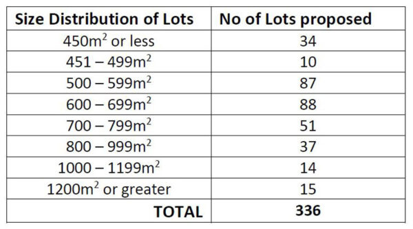
“Of the 336 residential lots 34 (10.1%) are 450m2 or less to meet CVC’s affordable housing requirements and 66 (19.6%) are 800m2 or greater,” the statement of environmental effects outlines.
“The latter meet the Residential Development Control Plan’s minimum site area for developments such as dual occupancies, residential flat buildings and multi-dwelling housing, all of which are permissible in the R1 zone.”
Lot 143 (2,142m2) in the B1 Neighbourhood Centre zone will “provide a range of small-scale retail, business and community uses that serve the needs of people who live or work in the surrounding neighbourhood”.
The council adopted the James Creek Urban Growth Area Road Infrastructure Developer Contributions Plan in February, 2020 – this plan outlines specific projects that will “ensure that adequate road infrastructure is provided to meet the demands generated by new development,” the contributions plan states.
This includes raising part of Gardiners Road to 1:20 year flood level so as to prevent isolation of the area during floods.
Water and sewage services will connect to CVC’s reticulated systems: the water to a water main that was extended at the same time the eastern end of James Creek Road was sealed; and sewage will be pumped through a rising main to connect with CVC’s system at Townsend.
A single public park is provided (Lot 144 – 3,910m2).
The existing site is pasture and virtually free of trees (three immature trees are marked for removal); a mature hollow-bearing tallowwood tree will be retained.
The biodiversity assessment notes that “no wildlife corridors or key habitats are depicted at or in proximity to the site”.
“Local agricultural clearing has contributed to increased fragmentation and habitat isolation to patches of vegetation proximate to the site,” the assessment states.
“Based on the desktop analysis and habitat present, several threatened fauna species have potential to occur at the site and surrounds on an opportunistic basis.”
Archaeologist, Yaegl elder Uncle Ron Herring, examined the site in 2009, for a previous DA that was not approved.
“Upon completion of the field study, research and consultation, no other evidence could be found of sites of significance and I don’t see any reason that the development cannot go ahead.”
In 2020, Mr Herron wrote: “The proposed development has had an extensive land clearing therefore it is expected that the proposed development would not impact on Aboriginal heritage values.
“However, if any material of Aboriginal origin be located whilst excavation or ground disturbance is taking place, work should cease immediately, and the project manager and the Aboriginal cultural officer should be notified immediately.”