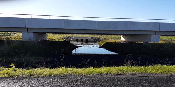
Chatsworth Island resident Shane Williams is taking no chances when it comes to putting the NSW Government on notice, telling it that he fears the new highway will increase the height and duration of future floods in the Lower Clarence.
Mr Williams, proprietor of Walla Walla Bing Bang Early Learning Centre at flood-prone Harwood, used the Clarence Valley Ratepayer, Residents & Business Owners Facebook page as a means of publicising his proposal on July 11, asking: “Has Maclean, Harwood, Ashby and Chatsworth been sacrificed in the next flood?
“The new highway on the northbound lanes has created a huge dam wall.
“…They have a bridge opening of 10 spans and modelling to allow flood waters to flow BUT they left the plug in and blocked the flow.
“They left the old highway in front of the openings, creating a dam.”
Mr Williams engaged a solicitor to write to the government about his concerns; last week he received a response from Transport NSW project director Greg Nash, outlining the processes taken to construct the highway in relation to a “request for design and flood mitigation information”.
Mr Williams was not satisfied with the response and wrote on the ratepayers Facebook page: “…they do say there will be a minor increase in flood to the western side [of the highway] and a lower flood to the east side of the highway.
“I do think it’s time to get our own advice from a hydrologist, before it’s too late, as a La Nina is forming this year,” he wrote.
Mr Williams said he had taken a proactive stance, pre-empting any future flood worsened by the highway’s construction, “to protect my house; it costs me $30,000 for flood insurance, although we don’t take it, so we are self-insured”.
Mr Williams is advocating the construction of duplicated carriageways across Harwood and Chatsworth islands, rather than reusing/reshaping the old highway for the dual southbound lanes.
“The new northbound carriageway between Watts Lane and Iluka Road has been built to maintain the flow of traffic during a one in 20-year flood,” Mr Nash wrote.
“The southbound carriageway is overtopped in a higher than one in five-year flood.
“In this scenario, southbound traffic will be moved to the new northbound carriageway in a contra flow arrangement.”
However, it is Mr Williams’ previous experience during a flood disaster that is most compelling; his businesses were victims of the 2011 flood that swept down the Lockyer Valley and subsequently devastated Brisbane.
“Up there they blamed the railway line, which created a steering effect,” he said.
Ironically, a similar scenario, regarding flooding caused by the construction of a new railway line through the Lockyer Valley, is currently an issue, too.
“‘Following the catastrophic floods of 2011 and 2013, and two Commissions of Inquiry, communities in the Lockyer Valley remain extremely sensitive to the contribution railways may have to the impacts of flood events,’ the regional council says,” the Brisbane Times reported in June this year.
“‘This issue has been raised consistently throughout the design process to date. It remains of fundamental importance to the region.’”
Three of Mr Williams’ childcare centres were destroyed in the 2011 flood.
“Itpushed the walls out at the Laidley and Gatton centres,” he said.
Mr Williams has started a Go Fund me page “to engage a hydrologist to do a flood study on the effects of the new Pacific Highway, [from] Ferry Parkto the Mororo Bridge”, with a goal of raising $4,800.
“This will help with any further actions the community can use in any future action against main roads and the NSW Government,” he wrote.

Note: the Independent is awaiting a response from Roads and Maritime Services, which advised it would not be available until this Thursday, due to the complexity of the paper’s enquiry.

How the new highway affects flood levels,‘generally’ speaking: www.clarencevalleynews.com.au/how-the-new-highway-affects-flood-levelsgenerally-speaking